Backpacking in Bruce Peninsula National Park - A Trip Review
- shawnaexplores
- Jun 17, 2025
- 9 min read

When thinking of backpacking trails in Southern Ontario, there is one iconic location that is hard to beat in terms of scenery along the trail - and that's Bruce Peninsula National Park.
When I started hiking the Bruce Trail five years ago, I soon discovered the beauty of the Bruce Peninsula - crystal clear, turquoise water and views that span miles. I dreamed of backpacking here before I ever started camping! This spring, I finally decided to make this dream a reality and got lucky snagging permits without too much effort. Fresh out of the backcountry for the weekend with my friend Carlie (check out her adventure family blog here), I thought I'd give you all the details on the experience, from planning to hiking, so you can start dreaming of your next Ontario hiking adventure! If you're interested in the nitty-gritty details, including permits and facilities, be sure to keep reading!
The Bruce Peninsula Backpacking Trip Report
Day 1: Cyprus Lake to Stormhaven via The Grotto
We met up in Wiarton to fuel up with lunch at the Sand Witches food truck (if you like pickles, the pickle poutine is a need). Then it was time to head to the Halfway Log Dump parking area to leave our second vehicle - this would be our finishing point since we would be hiking southbound. We then headed to the Cyprus Lake campground office to check in - 4 pm on a Friday in June was pretty busy, so pack your patience!
After completing the paperwork, it was finally time! We parked at the Grotto lot, ready to begin the adventure. Since the Grotto isn't directly on route to Stormhaven, you have two choices if you want to visit this spot (and trust me, you do!). You can either take the Georgian Bay Trail and then head west along the Bruce Trail, which requires some backtracking when you return east to Stormhaven, or you can loop clockwise around Marr Lake to avoid backtracking. I opted for the latter, which proved to be more challenging as we navigated Boulder Beach before reaching the Grotto. The Georgian Bay Trail is flat and wide, making it a great option if you prefer a more relaxed start to your day!
Even on a drizzly Friday evening, the Grotto was somewhat busy, so we only stayed long enough to take a few photos and videos before moving on. The section of the Bruce Trail in the National Park is known to be the most challenging part of the entire trail, and while it is quite technical for southern Ontario, I'd rate it as moderate if you have hiking experience outside the province. If your hiking experience is limited to Ontario, you'll likely find this trail difficult! We passed many more beautiful lookouts on the way to Stormhaven. When we arrived at camp, we needed to set up and cook dinner in the drizzle, which finally eased just in time for us to head down to the beach for sunset and dessert. It turns out great minds think alike, as we both brought the exact same dessert to share, so we enjoyed a sweet treat both evenings! The post-rain skies offered us gorgeous pastel colors for sunset, and we relaxed for quite a while before heading to the site and finally lying down for the night.


Distance: 5.34km
Elevation Gain: 122m
Time: 2 hours moving/ 2:16 total
Day 2: Stormhaven to High Dump
Waking up early for sunrise (and blissfully, no rain), we headed down to the beach and had it all to ourselves. Once the sun finished rising, we headed back to bed and proceeded to sleep in until nearly 10:30, which was much needed for both of us. We took our time with breakfast, and around noon, we packed up and hit the trail for the longest and hardest day of the weekend.
It's 2.7 km to Halfway Log Dump, another popular location within the National Park. Upon reaching the intersection, you can take a short trail to the beach if you'd like to check it out. This spot offers another stunning view of Georgian Bay and is your last opportunity to filter more water if necessary. Facilities such as toilets and picnic tables are available, making it an excellent place for a break before continuing the final 6.7 km to High Dump. As you proceed south, the technical difficulty increases. The terrain is mostly rocky, even without significant elevation changes. You'll encounter a few brief scrambles and some rocky climbs requiring you to use your hands (or possibly bum scoot when going downhill) that might make you question if you're still on the trail! Fortunately, the Bruce Trail is well-marked, so by watching for the white markers, you'll easily stay on course.
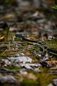
Be aware that Massasauga rattlesnakes inhabit the Peninsula. We encountered a group of anxious hikers who asked quite a few questions about these snakes and whether they were "poisonous" if bitten. We clarified that they are indeed venomous, and while a bite is unlikely to cause severe problems, it's important to seek medical attention promptly. We inquired if anyone had been bitten, and they said no, but we weren't entirely convinced. Cellular service is unreliable here, so I highly recommend a satellite device (I have a Zoleo, which balances cost and functionality well). Review snake safety before your visit, but in short - If bitten, remain calm and still while awaiting assistance. Black bears are also present in the area (although we didn't see any on this trip, I have before!), so bear spray is another worthwhile investment for your trip.
The remainder of the day's trail followed the edge of the escarpment, offering occasional breathtaking views of the turquoise waters. Eventually, the trail veered inland, leading to the High Dump Side Trail. This section descends a steep hill, with ropes available for support. It is the most challenging part of the entire trail! Campsites here are more dispersed and private. After descending the hill and locating the marker for your campsite, you'll need to climb back up to your tent pad. Numerous small paths lead from the forest to the beach for easy access. On the beach, there aren't many rocky ledges to perch on for filtering water, so I suggest bringing waterproof camp shoes (I use Merrell Hydro Mocs), or you can venture in barefoot, though the rocks can make it a bit tricky.
The loons were calling all night long, and I wish I had brought earplugs with me - but it was nice falling asleep to the sound of waves lapping along the shore.


Distance: 9.44km
Elevation Gain: 293m
Time: 3:28 hours moving/ 4:28 total
Day 3: High Dump to Halfwy Log Dump
While I didn't get up for sunrise, I woke around 7 am (nature calls!) and then headed down to the beach. The water was so calm and peaceful, I spent quite a bit of time just soaking in the serenity before my stomach started rumbling. I headed back to the tent for my Kobo Reader and invited Carlie down to the beach, so we grabbed our food bags and headed back down. We brewed our coffee, ate, and enjoyed reading for a while, soaking in the peace and privacy before reluctantly admitting that we should get a move on. The day was heating up, so luckily the tent was nice and dry.
It was time to backtrack the 6.7 km to Halfway Log and then take the 900m side trail back to the parking lot. Motivated by the thought of tacos and gelato in Tobermory, and with fewer photo stops on the now familiar terrain, we made good time. We took a quick snack and restroom stop at the Halfway Log intersection before finishing the final stretch to the car. It felt much easier hiking this stretch northbound, since many of the scrambles were downhill, which can be trickier to navigate but easier on the lungs. There is no water access along the trail once you leave camp, so make sure to filter enough water for the day.
Every good hike deserves a reward, so we returned to pick up my car (they gave us a pass to scan in at the gate), showered at the Cyprus Lake Campground, and headed into Tobermory. Our first stop was the Tacomory Food Truck, where we got tacos, nachos, and Corona Sunbrews, and then it was time for gelato at Stella's. Wandering around the town and watching the boats come in was the perfect way to wrap up the weekend before saying our goodbyes.


Distance: 8.07km
Elevation Gain: 219m
Time: 2:25 hours moving/ 2:47 total
Permits
Camping fees are per person / per night and do not include extras like parking and day use, which are paid separately at check in. If you have a Parks Canada pass, be sure to bring it with you into the office so you don't have to pay twice. Be sure to arrive with plenty of daylight hours to make it to camp before nightfall, or staff will not issue your permits.
Parking
We originally intended to hike from Cyprus Lake to Crane Lake Road, but spring flooding disrupted our plans. The road to the southern trailhead is flooded due to the spring melt, so we had to park our second vehicle at Halfway Log Dump and backtrack on our last day.
For backcountry permits, parking is not included in the fee, and you will pay an additional fee for per vehicle when checking in at the Cyprus Lake campground. Since we were finishing at Halfway Log Dump, we parked our second vehicle there first before checking in to avoid backtracking, and left a printout of our booking, which showed the dates and site numbers of our reservation, along with a little note that we didn't want to backtrack. We had no issues and didn't get ticketed.
When checking in, we did explain that our second car was at Halfway Log. The employee got mixed up, and our vehicle permit wasn't scanning at the gate to let us into the Cyprus Lake parking lot. A huge queue of cars was forming behind us while Carlie sorted it out inside and got a new sticker printed to affix onto the permit and scan us in, so do your best to make it very clear where you need to park so you can avoid this!
If the road to Crane Lake isn't closed, it is often still partially flooded - I have driven here for day hikes, and have been told it's best to drive straight through the middle since the gravel shoulders will just sink in. If you have a car with low clearance, you may want to consider hiring the Crabby Cabbie out of Wiarton to take you there instead of making the drive yourself.
The Campsites
All campsites have:
Tent pads (freestanding tents only per park rules) - there plenty of rocks available instead of tent stakes (so save weight - you don't have to pack them!)
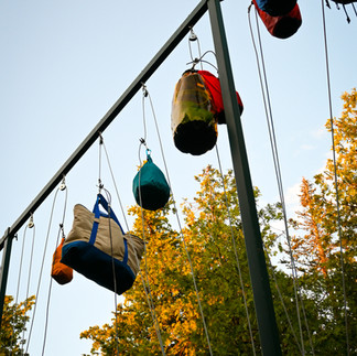
Communal bear hang poles - we saw people hanging plastic garbage bags, which is not recommended, since birds can easily tear these open and release trash, attracting bigger wildlife to the area. Use dry bags or proper bear storage bags for your food and other attractants like toiletries!
Composting toilets with toilet paper and hand sanitizer provided (although they may run out, so bring your own - we both forgot hand sanitizer and Stormhaven was empty!)
Nearby water sources for filtering (at most a few minutes walk to the beach)
Open fires aren't allowed, so you must bring a stove and fuel if you want to boil water and cook food.


We had site 3 at Stormhaven, which was the closest to the toilet, but the two sites beside us occupied by quite a large group of women. They passed by our site quite regularly, so it wasn't very private. If you have the choice, and you don't mind a longer walk to the toilets, I'd opt for the sites further away where fewer people walk by. There is no cell service at this campsite.
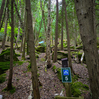
At High Dump, we had site 5 - also the closest to the toilets, which in this case was an advantage since this campground is quite hilly. There's a bit of a direct path you can take to the toilet from this site instead of having to walk downhill and then back up. This is also closest to the bear hang, but we didn't notice too much noise from people using it. You may get minimal cell service here.
Which direction should I hike?
We didn't get a choice based on site availability, but in hindsight, I think southbound was the way to go. Stormhaven was less private and a little noisier as a result. High Dump was so secluded and much quieter, even with our site being closest to the toilet and bear hang. It was nice to have the quieter site on night two, and we really enjoyed this one. If you're able to walk to the Crane Lake trailhead to finish your hike, the trail is much easier just south of High Dump - this will make for a quick and easy last day of hiking.
What Should I Pack?
I'll have a whole blog post with my packing list coming soon!
Between the epic scenery, the stunning sunsets and sunrises, and the amenities (toilets and hand sanitizer, I'm looking at you!), we had an incredible backpacking experience and felt spoiled by this trail. If you're a beginner backpacker but have a little experience with technical terrain, this is a great place to dip your toe into the backcountry - and if you're experienced, you can't beat the Bruce Peninsula views. This trip did not disappoint, and I will be back again!
Have you hiked in Bruce Peninsula before, or is this one on your bucket list?
See you on the trails!
Shawna
**Post may contain affiliate links, which provide a small commission to support the blog at no cost to you.